Cell Tower Fallback
Table of Contents
Many devices support 'cell tower fallback' for location.
On battery powered devices, this is used to provide a rough location if a GPS (or Wi-Fi) fix fails. This can be useful in extending the localization abilities of a device.
Applies to:
| Device | Firmware Version |
| Barra GPS | All FW versions |
| G150 | All FW Versions |
| Oyster3 | All FW Versions |
| Oyster3-BLE | All FW Versions |
| Oyster3-Global | All FW Versions |
| Remora3 | All FW Versions |
| Remora3-Global | All FW Versions |
| Dart3-Global | All FW Versions |
| Yabby3 | All FW Versions |
NB: Our ‘Core’, ‘Edge’ and ‘Fusion’ Range of devices also make use of Cell Tower data and Wi-Fi access point data, along with Digital Matter's Location Engine in order to resolve a position when no GPS data is available – either due to the device being indoors (Edge and Fusion), or the device not supporting GPS at all (Core).
See Indoor/Outdoor Tracking.
In the case of Edge devices, on every connection, Cell tower information is recorded and sent to the server. During any upload, the device performs a scan and immediately transmits this data.
This article refers to our ‘traditional GPS’ devices - where Cell Tower data can be sent should a GPS fix fail.
*The G150 can be configured to fall back to cell tower location if GPS Jamming is detected. For details see GPS Jamming and Interference Detection
Platform Support
A cell ID in and of itself does not provide a GPS coordinate location (latitude/longitude) - it has to be passed on to a location service (like Google's Geolocation API or other) which retrieves an approximate location (for a fee).
Telematics Guru supports viewing the raw Cell ID data, for all devices that currently support Cell Tower fallback.
3rd party platforms are able to implement this if required.
Set up (battery powered devices)
- Ensure your device firmware supports the feature
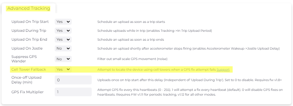
- Set the Cell Tower Fallback parameter to YES (found under the Advanced Tracking parameter tab)

Set up (hard-wired devices)
- Ensure your device firmware supports this feature
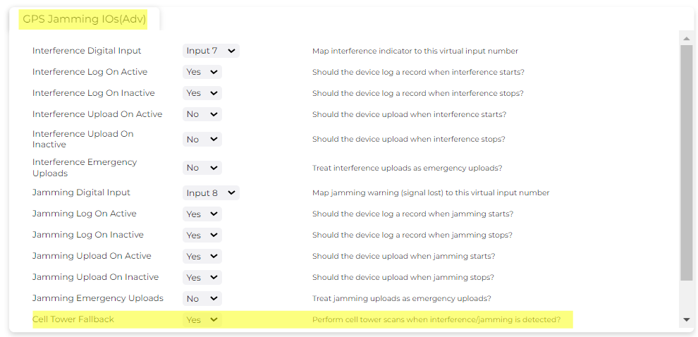
- Set the Cell Tower Fallback parameter to YES on the GPS Jamming IOs parameter tab.

Multi-Cell Tower Scanning
Applies to Yabby3.
By default, when cell tower fallback is enabled, it will scan and record one cell tower. The Yabby3 allows for multi-cell tower scanning to be enabled to return additional cell tower information.


How does it work?
Cell Tower Scan
For battery-powered devices, such as the Barra GPS, each connection involves collecting basic cell ID data (MCC, MNC, and Cell ID). This data is then logged into the Debug logs (FID 1) at the INFO level.
If a GPS fix fails, or GPS is being jammed, ONLY then a cell tower scan is QUEUED. For example, during a trip with 2-minute fixes and 30-minute uploads, if GPS is lost, scans will only be performed at the next upload, not every 2 minutes. Do note that by default, trips will time out if no GPS is available for approximately 5 minutes.
The serving tower is returned. The device will then report to the server:
- Cell ID
- Location Area Code
- Mobile Country Code (MCC)
- Mobile Network Code (MNC)
For integrators - this is Field 28 in the integration documents. Any cell scan results will be sent as an upload with log reason 49 - Cell Tower Connection. Field 36 in the integration documents details the multi-cell scan results (applies to the Barra GPS and the Yabby3-4G if configured). The Cell Tower data field can be sent to third-party servers via HTTP or TCP connectors, or directly to Telematics Guru (TG). In TG, this data is not resolved into a specific location; instead, the Cell ID is listed. However, this data can be sent to an open-source locator for further analysis. Please see how to enable this below.
Determining the location (Lat/Long)
These values in an of themselves don't constitute the Latitude and Longitude of the device for display on a map. The position must be calculated and this can be done through various location services like Google's Geolocation API. The data can be passed to this service via API call and the Lat/Long is returned. Services of this nature charge a fee per lookup or per month.
Accuracy
The cell scan is typically accurate to within 1km. On NB-IoT, it can be much worse as the cells are wider.
So it is useful for a rough idea of where your device is i.e., 'has it left the depot?', what suburb am I in?, not ‘what street am I on?’
Applications
As mentioned, the accuracy of a Cell Scan is not great in comparison to a GPS fix. It can be useful as a 'last resort' fix. If you are expecting to be regularly indoors, the Edge device range may be a better choice. Additionally the cost of look-ups must be factored in to the equation - however this feature is useful for:
Tracking assets in shipping containers
Often GPS fixes will fail when a device is placed inside a shipping container, but the device can still connect to the cellular network. When out in the field, the asset can be tracked via GPS. A typical problem is that once the device is loaded into the container and GPS fixes fail, we may be able to get uploads but we lose all visibility of device location. It will report the exact same GPS location (i.e. the last valid fix) until the container is unloaded (maybe not until it reaches another country!) Cell tower fallback is enough to give us a rough location, so we know it left the port/depot/warehouse - which is invaluable when managing the movement of shipments as an operational tool.
Theft/tampering prevention
The ability to fall back to a cell location while GPS is jammed means we can still track a devices rough location in the event of jamming. Thieves may attempt to jam GPS signals, if successful, the device will stop updating it's location as it cannot acquire new GPS fixes. Cell Fallback will give a rough location and may enable the asset to be recovered.
Cell Tower Fallback on Telematics Guru
The devices will send Telematics Guru the raw Cell Tower data which is stored in the Telemetry. Google's Geolocation API may be used to calculate the device's position should you require an estimate, i.e. when recovering an asset.

To view the Cell Tower Data button - the organization must have Cell Tower Data functionality enabled.

Mapping MCC and MNC to analogues
Note: Requires Dart3 2G firmware version 1.12
The Dart3 2G allows for mapping of the Mobile Country Code (MCC) and Mobile Network Code (MNC) to analogues, to easily see which network the device has connected to. These values will be stored in analogues 6 and 7 respectively.
This data will come through every heartbeat and will additionally come through with every cell tower scan if enabled as per below.

This can come in handy, for example, to compare the number of device connections to a home network versus a roaming network.
